Locating the exact spot where the Dallas Patrolman fell
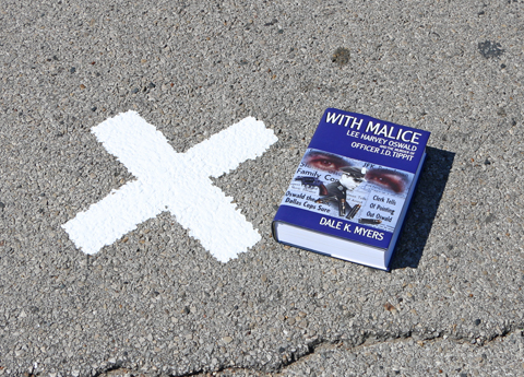 |
The new 'X' on Tenth Street. (F. Badalson)
By DALE K. MYERS
Anyone familiar with the assassination story knows that J.D. Tippit, the Dallas Patrolman gunned down forty-five minutes after the assassination of President Kennedy, was shot just east of Tenth and Patton in Oak Cliff.
Given the changing landscape over the last fifty-nine years, those who have ventured to the location have had a difficult time determining the exact spot where Tippit fell.
In the last few years, someone placed an “X” (using white tape) on Tenth Street to mark the spot where Tippit was presumably shot dead – a courtesy, presumably, to the steady stream of tourists that frequent the area.
I don’t know who was responsible for choosing the spot to place the white-X, but unfortunately, as I pointed out in a 2021 blog article,
the spot is wrong.
In August, researchers Bill Brown and Frank Badalson proposed correcting the erroneous marked-spot, with a newly painted ‘X’ that properly located the exact spot where Tippit met his fate.
I offered to help them determine the location and set about creating a series of exhibits based on Oak Cliff property plat maps, 1963 Dallas police crime scene photographs and diagrams, 1964 FBI schematics and photographs, and personal photographs I had taken at the location between 1985 and 2013.
On September 30, 2022, in the interest of preserving history for future generations, Bill and Frank traveled to the location, made the appropriate measurements and painted an ‘X’ at the spot where Tippit died.
Here’s how I correlated the visual materials and determined exactly where Tippit was gunned down.
The Dallas police investigation
The primary source for fixing the spot where Tippit died was a series of photographs and a diagram of the crime scene made by the Dallas police on November 22, 1963.
Between 1:47 p.m. and 1:50 p.m. that afternoon, Dallas police Crime Scene Search Section Sergeant Willie E. “Pete” Barnes made six photographic exposures documenting the position of Tippit’s squad car on Tenth Street. Starting at the right-rear quarter panel, and moving in a counter-clockwise direction around the car, Barnes not only captured the position of the car but also recorded the relationship of the car to the pool of blood that marked the spot where Tippit fell. [1]
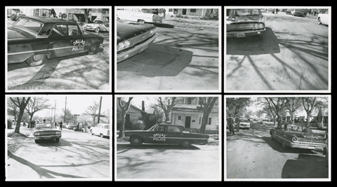 |
FIG. 1 – Six DPD crime scene photographs. (DMARC)
In addition to the photographs, Barnes created two hand-drawn diagrams noting the order in which the photographs were taken as well as measurements made at the scene. [2]
The diagrams show that the spot where Tippit fell was measured at 114 feet east of the Patton Avenue eastside curb line and 13 feet from the south curb of Tenth Street. Sergeant Barnes also noted that the width of both Patton Avenue and Tenth Street was thirty-two feet. [3]
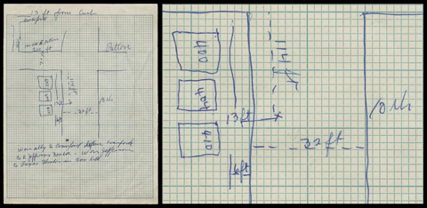 |
FIG. 2 – One of two crime scene diagrams (left) drawn by Barnes at the scene; and a detail of the same (right). (DMARC)
Eight additional photographs related to the Tippit shooting were taken by Sergeant Barnes between 2:03 p.m. and 4:15 p.m.
Two of the eight photographs, taken between 2:03 p.m. and 2:05 p.m., show the parking area behind the Texaco service station located at 401 E. Jefferson, where a discarded jacket was found; and four photographs were taken between 2:07 p.m. and 2:15 p.m. at the Texas Theater where Lee Harvey Oswald was arrested. [4]
Barnes returned to the Tippit shooting scene around 4:00 p.m. and took two photographs of the stop sign knocked down at the southeast corner of Tenth and Patton. [5] Police thought it might have something to do with the shooting, however, it was later determined that the sign had been damaged during an automobile accident earlier that morning.
After the fourteen crime scene photographs were developed, eleven were selected for possible use in a forthcoming trial. Barnes dated and signed the reverse side of each photograph (“W.E. Barnes, 11-22-63”) and wrote a short caption in his own hand.
The 11 selected photographs were then placed in a manila envelope [6] along with a twelfth photograph – an image of the scratch on arresting officer M.N. “Nick” McDonald’s face. Included in the envelope was a typed list of the photographs enclosed. [7]
Even a cursory review of these materials shows several discrepancies.
Photograph No.7, one of two photos showing the stop sign knocked down at the corner of Tenth and Patton, contains the following handwritten notation on the reverse side: “View of 10th & Patton – Tippit shot 132 ft East of Curb Line.”
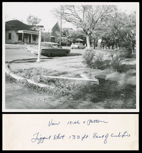 |
FIG. 3 – DPD crime scene photo No.7 (top) and notation on back (bottom). (DMARC)
The typed-list of photographs, presumably prepared by Barnes, also includes the same notation next to the listing for photograph No.7 – “Tippit shot 132 ft east of curb line.”
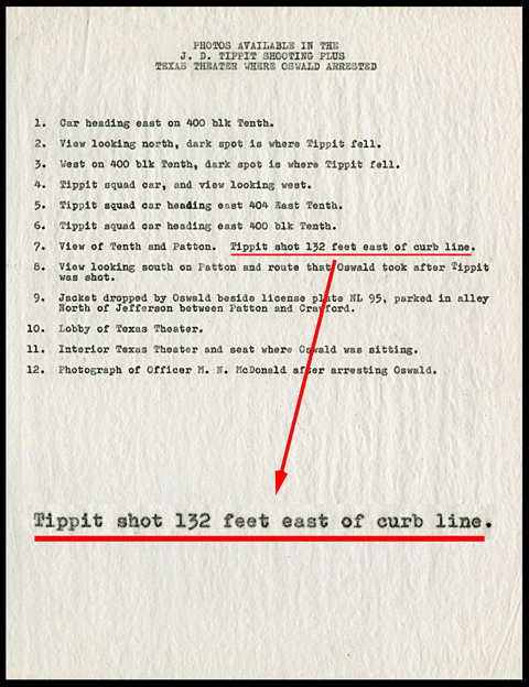 |
FIG. 4 – DPD list of Tippit photographs and 132 feet notation (red line + insert). (DMARC)
These notations are at odds, of course, with what Sergeant Barnes wrote in his diagram of the crime scene – notations of the measurements he made while on scene. At that time, Barnes wrote that Tippit was shot 114 feet (not 132 feet) east of the eastside Patton Avenue curb line.
Which measurement is correct? It seems more reasonable that the crime scene diagram made on scene would contain the correct figure. However, if I’ve learned anything in the course of studying this case, it’s this: assume nothing. Fortunately, there is a way to determine which measurement is correct.
FBI investigation
In 1964, at the request of the Warren Commission, the FBI conducted an investigation of the Tippit shooting which included taking photographs of the area and creating maps of the shooting scene and the surrounding area. The results of their investigation were published in a briefing booklet entitled: “Killing of Dallas Patrolman J.D. Tippit.” [8]
One of their maps depicts the area of the shooting and the location of Tippit’s squad car. [9]
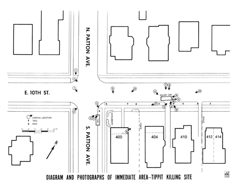 |
FIG. 5 – 1964 FBI diagram of Tippit Killing Site. (CD630)
The scale included with the FBI map shows that both Patton Avenue and Tenth Street were 30-feet wide – not 32-feet as recorded in DPD Sgt. Barnes’ crime scene diagram – yet another discrepancy worthy of investigation.
The scale also shows that the left front bumper of Tippit’s squad car was located 116-feet from the eastside Patton Avenue curb line.
This figure is closer to the 114-foot notation made by DPD Sgt. Barnes in his on-scene crime scene diagram than the 132-foot notation written by Barnes on photograph No.7 and the corresponding typed list.
Unfortunately, there is no way to know whether the FBI had positioned Tippit’s squad car in their diagram based on an actual analysis of the DPD crime scene photographs or by simply eyeballing it. So, measuring the its location relative to the eastside Patton Avenue curb line doesn’t get us any closer to the truth.
What is required is a remapping of the Tippit crime scene based on original source materials. The result should verify the exact location and orientation of Tippit’s squad car as well as the relationship of the pool of blood (marking the spot where Tippit fell) to Tippit’s squad car.
Once remapped, the resulting measurements can be applied to the Tenth and Patton area as it exists today, revealing once and for all the exact spot where Tippit died.
Remapping the crime scene
In order to create a new map of the crime scene, I relied on the crime scene photographs taken by DPD Sgt. Willie E. “Pete” Barnes about thirty-two minutes after the shooting.
I was particularly interested in two of the photographs – Nos. 4 and 5 – which showed Tippit’s squad car from two vantage-points:
- Head-on, looking west (No.4), and
- Left-profile, looking southeast (No.5)
I was confident I could deduce the angle at which Tippit’s squad car was parked from these two photographs.
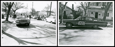 |
FIG. 6 – DPD crime scene photographs No. 4 (left) and No. 5 (right). (DMARC)
While the pool of blood, where Tippit fell, is clearly visible in several crime scene photographs (including No.4), it’s not visible in the left-profile photo (No.5).
As luck would have it, two left-profile photographs of Tippit’s squad car were taken by Dallas Times Herald photograph Darryl Heikes at about 1:43 p.m. – just before Barnes snapped his police photos. The two Heikes photos do show the pool of blood in relation to Tippit’s squad car. [10]
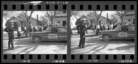 |
FIG. 7 – DTH photographer Darryl Heikes exposures No. 9 and 10. (The Sixth Floor Museum at Dealey Plaza)
Using overlapping features visible in both DPD crime scene photograph No.5 and Darryl Heikes photograph No. 9, I was able to create an accurate composite photograph that shows the orientation of the blood pool in relation to the front of Tippit’s squad car
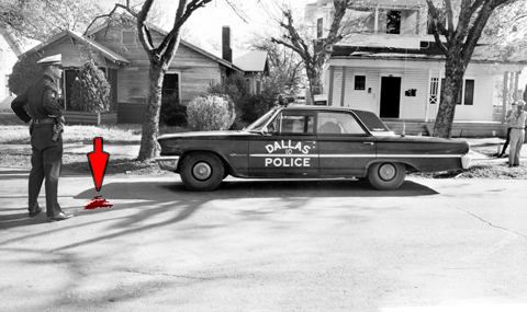 |
FIG. 8 – Composite image of DPD crime scene photograph No.5 and DTH Darryl Heikes exposure No.9 showing blood pool (arrow) (© 2022 Dale K. Myers. All Rights Reserved)
Accuracy of the FBI diagram
To ensure the accuracy of the 1964 FBI diagram published in their briefing booklet, I obtained a plat map of the properties in the Tenth and Patton area from the city of Dallas.
I then superimposed the 1964 FBI diagram over that plat map and aligned it with the properties shown. Both maps were in agreement with each other. This verified that the FBI diagram was to scale.
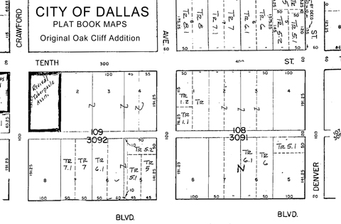 |
FIG. 9 – Detail of City of Dallas, Plat Book Maps, Original Oak Cliff Addition
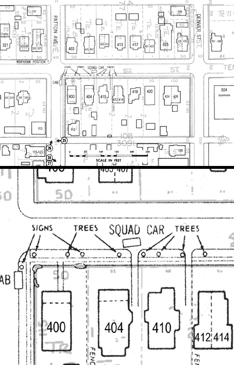 |
FIG. 10 – Overlay of 1964 FBI diagram of Tippit scene and City of Dallas, Plat Book Maps, Original Oak Cliff Addition (top); with detail (bottom) (© 2022 Dale K. Myers. All Rights Reserved)
To double-check the accuracy of the 1964 FBI diagram, I superimposed it over a current Google satellite image of the Tenth and Patton area. Again, the result shows that the FBI diagram is accurate and to scale.
The result also shows the changes in construction that took place in the area between 1964 and 2022. In particular, the overlay reveals where the concrete two-track driveway running between the properties at 404 and 410 E. Tenth Street was originally located before construction altered the area. Tippit stopped his squad car adjacent to this driveway on November 22, 1963.
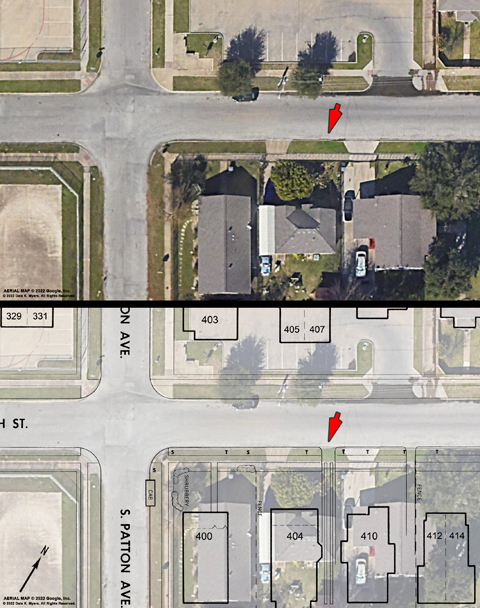 |
FIG. 11 – Google satellite image (top); and same with 1964 FBI diagram overlay (bottom). Arrows show the location of the driveway that Tippit stopped adjacent to in 1963. (© 2022 Dale K. Myers. All Rights Reserved)
Locating Tippit’s squad car
The first step in locating Tippit’s squad car was to perform a vanishing-point analysis of DPD crime scene photograph No. 4 and the composite image I created from DPD crime scene photograph No. 5 and Darryl Heikes photograph No.9.
The “vanishing-point” is the point on the image where parallel lines in three-dimensional space appear to converge. [11]
The idea was to create a scale for each photograph based on the known length and width of Tippit’s squad car and then use it to measure other distances visible in each photograph that lie in a plane perpendicular to the camera’s line of sight.
Based on this analysis, which provided two intersecting vantage points, I could determine the position and orientation of Tippit’s squad car and pinpoint the location of the spot where Tippit fell (as designated by the center of the blood pool).
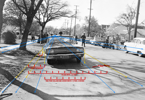 |
FIG. 12 – Vanishing point analysis of DPD crime scene photograph No. 4. (© 2022 Dale K. Myers. All Rights Reserved)
The analysis of DPD crime scene photograph No. 4 shows that the right front bumper of Tippit’s squad car was 2 feet, 8.5 inches from the south curb line; and the right rear bumper was 13.5 inches from the curb line.
To achieve this orientation, Tippit’s squad car would had to have been rotated five-degrees counterclockwise relative to the east-west orientation of Tenth Street.
This five-degree figure was verified after performing a similar vanishing point analysis on the composite image (DPD No.5 and Heikes No.9).
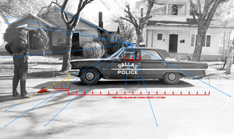 |
FIG. 13 – Vanishing point analysis of composite image of DPD crime scene photograph No. 5 and Darryl Heikes photograph No.9. (© 2022 Dale K. Myers. All Rights Reserved)
The composite image vantage point looks southeast. Tippit’s squad car is seen in near-perfect profile. The DPD camera that recorded Tippit’s squad car is perpendicular to the southside Tenth Street curb line as demonstrated by the western-most concrete two-track driveway visible through the driver-side and passenger side window of the squad car.
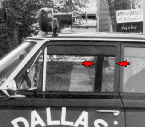 |
FIG. 14 – Detail of DPD crime scene photograph No. 5 showing the squad car’s relationship to the western-most driveway track (visible through the window) and the offset of the driver’s side and passenger side window frames (arrows) due to the five-degree counterclockwise rotation of the squad car in relation to its direction of travel. (© 2022 Dale K. Myers. All Rights Reserved)
The difference in distance between the window frame edge on the driver’s side and the window frame edge on the passenger side (arrows) is six-inches. It was determined that to achieve this orientation, the squad car would have to be rotated five-degrees counterclockwise relative to the east-west orientation of Tenth Street. Again, this verifies the orientation of Tippit’s squad car as previously determined from DPD crime scene photograph No. 4.
A model of Tippit’s squad car can now be positioned on the map in the correct orientation and location.
An aerial image of a Dallas police 1963 Ford Galaxie 500 four-door sedan was obtained from news film footage shot on November 22, 1963. The image was scaled to match the 17.6-foot length and 6-foot, 8-inch width of Tippit’s squad car.
The front driver and passenger side window frames were marked with light-blue rectangles.
The squad car image was rotated five-degrees counterclockwise relative to the east-west orientation of Tenth Street and positioned on the map so that the window frames were aligned with the western-most concrete two-track driveway that ran between the properties at 404 and 410 E. Jefferson (as seen in DPD crime scene photograph No.5).
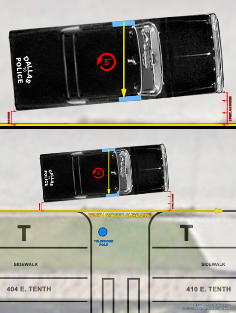 |
FIG. 15 – Final orientation of Tippit’s squad car. Blue rectangles represent location of front side-windows. Yellow arrow aligns with center of western-most driveway track. (© 2022 Dale K. Myers. All Rights Reserved)
The squad car image was then positioned so that the right-rear bumper was 13.5-inches from the south curb line of Tenth Street. Measurements show that the right front bumper was 2-feet, 8.5-inches from the south curb line of Tenth Street. This matched the measurements obtained from the vanishing-point analysis performed on DPD crime scene photograph No.4, verifying the accuracy of the squad car’s placement and orientation.
Locating the spot where Tippit fell
According to the vanishing point analysis of DPD crime scene photograph Nos. 4 and 5, the blood pool marking the spot where Tippit fell should be 3-feet, 8-inches north of, and 1-foot, 10-inches east of the left-front bumper of Tippit’s squad car.
This spot was marked on the map with a yellow ‘X’. Measurements were then made from the eastside Patton Avenue curb line and the southside Tenth Street curb line.
The results show that the center of the blood pool, as deduced from photography, was 114-feet from the eastside Patton Avenue curb line and 13-feet from the southside Tenth Street curb line – just as DPD Crime Scene Search Sergeant Willie E. “Pete” Barnes wrote on his crime scene diagram on November 22, 1963.
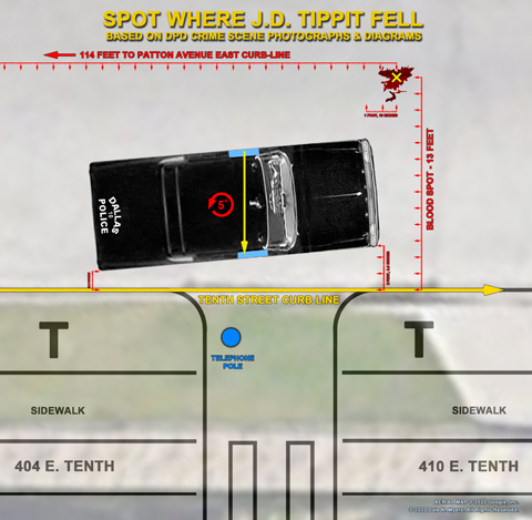 |
FIG. 16 – Diagram showing location of spot where Tippit fell (yellow ‘X’) in relation to Tippit’s squad car as deduced from DPD crime scene photographs. (© 2022 Dale K. Myers. All Rights Reserved)
So, in fact, the measurements contained on the DPD crime scene diagram, produced on-scene by DPD Sergeant “Pete” Barnes, are the correct figures.
How or why the discrepancies appeared in the record is anyone’s guess.
Current Google satellite imagery agrees with city property plat maps and the 1964 FBI diagram – the street width is 30-feet; not 32-feet as noted by DPD Sgt. Barnes on his crime scene diagram.
Photographs of the area taken in 1963 and 1964 clearly show a defined curb line and although the sidewalks and curbs, particularly at the intersection of Tenth and Patton, have been re-constructed since the shooting, there is nothing to indicate that the width of the roadways has changed.
DPD Sergeant Barnes’ notation on both Photograph No.7 and the corresponding typed-list that Tippit was shot 132-feet from the Patton Avenue curb line is clearly in error. If it were true, Tippit’s squad car would be positioned 18-feet (more than a car length) further east than the photographic record shows.
No doubt, these discrepancies would have come up at trial and corrected.
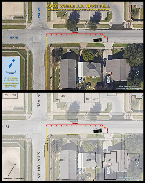 |
FIG. 17 – Overview diagram showing location of Tippit’s squad car and the spot where he fell as seen today (top) and in a 1964 FBI diagram overlay (bottom). (© 2022 Dale K. Myers. All Rights Reserved)
‘X’ marks the spot
On Friday, September 30, 2022, a team led by Bill Brown and Frank Badalson went to Tenth and Patton armed with the culmination of the research described above. [12]
They set out to verify the measurements determined from the original DPD investigation and paint a white ‘X’ on the exact spot where Tippit was shot dead.
First, the erroneous taped-X previously placed on the street was painted over to avoid any future confusion. (It was later determined that the erroneous ‘X’ was 25-feet west and five feet south of where Tippit was actually shot.)
Second, the team verified that the width of Tenth Street, curb-to-curb, was indeed thirty feet.
Third, the team used a tape measure to extend the eastside Patton Avenue curb line north until it intersected with a westward extension of the southside Tenth Street curb line. The intersection of the two lines was marked with chalk.
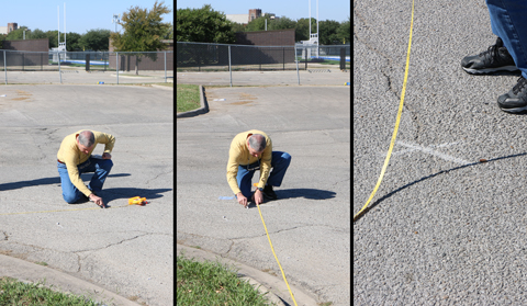 |
FIG. 18 – Frank Badalson marks the intersection of the Patton and Tenth street curb lines. (F. Badalson)
Fourth, a distance of 114-feet was measured from the eastside Patton Avenue curb line, eastward along the southside Tenth Street curb line, ending at a point about three feet west of the current driveway. This was accomplished in two steps using a 100-foot tape measure.
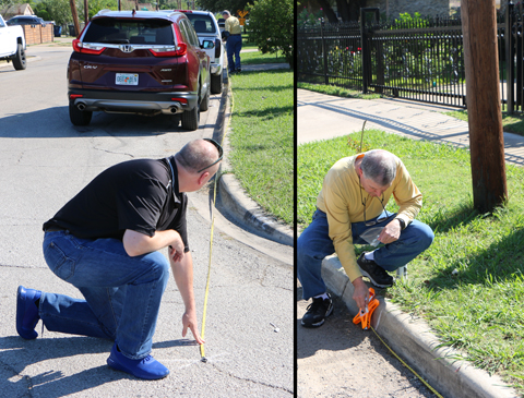 |
FIG. 19 – Step 1: Bill Brown (foreground, left) works with Frank Badalson (right) to measure a distance of 100-feet eastward from the Patton Avenue curb line. The 100-foot mark is noted on the curb with chalk. (F. Badalson)
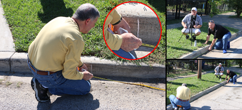 |
FIG. 20 – Step 2: Frank Badalson (left) marks the curb with chalk (inset) at a point 14-feet from the chalk-mark in Step 1 (a total of 114-feet from the eastside Patton Avenue curb line). Bill Brown assists while Matthew Kordelski takes a photograph. (F. Badalson)
Fifth, a distance of 13-feet was measured north from the southside Tenth Street curb line. This marks the spot where Tippit fell.
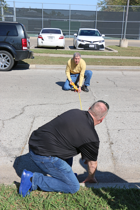 |
FIG. 21 – Bill Brown (bottom) and Frank Badalson (top) measure 13-feet out from the curb to find where Tippit fell. (F. Badalson)
Finally, a form was centered on the spot indicated, to protect the pavement, and the center ‘X’ was painted with traffic striping paint.
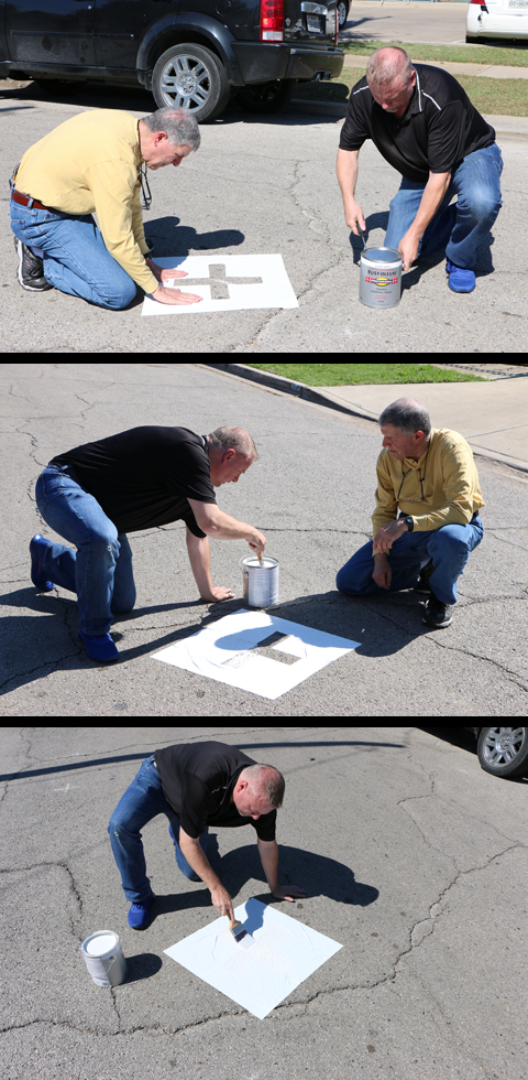 |
FIG. 22 – Frank Badalson (top, left) adjusts the form on the pavement as Bill Brown (top, right) readies the paint and begins filling in the ‘X’ on the form. (F. Badalson)
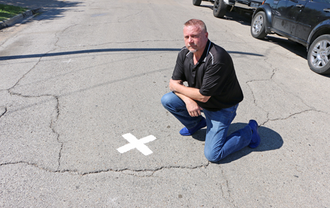 |
FIG. 23 – Bill Brown next to the newly finished ‘X’ marking the spot where Tippit died. (F. Badalson)
History Channel recreation
In 2013, I acted as a consultant to the History Channel’s documentary special “Oswald: 48 Hours to Live” and positioned a replica of Tippit’s 1963 Ford Galaxie 500 squad car at the location using the measurements and photographs taken by DPD Sgt. “Pete” Barnes in 1963.
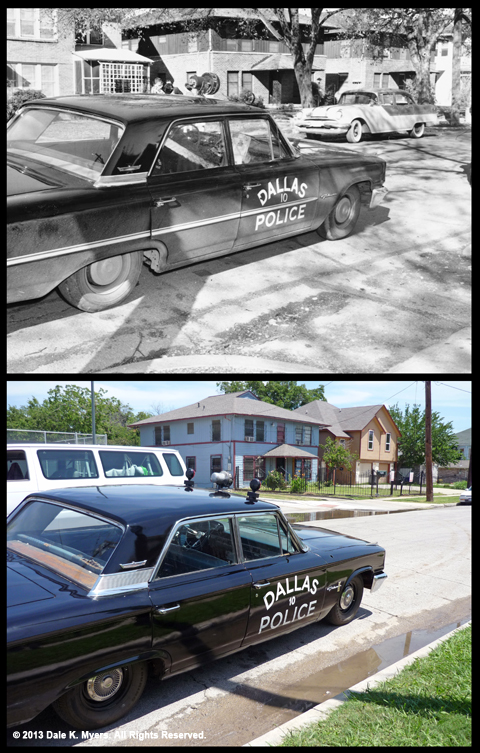 |
FIG. 24 – A replica of Tippit’s squad car positioned at the location during the filming of the 2013 History Channel special “Oswald: 48 Hours to Live.” (Top: DMARC 91-001/016 / Bottom: © 2013 Dale K. Myers. All Rights Reserved.)
The squad car was moved about slightly during filming to accommodate various camera angles required by the director of photography, so the squad car’s exact orientation relative to the curb was close, but not exact. Tippit’s squad car was about one-foot closer to the curb and angled more toward the center of the street in 1963 than seen in the photographs I took on set.
Still, superimposing the newly painted ‘X’ onto one of the 2013 re-enactment photographs, gives you a pretty good idea of where Tippit’s squad car was relative to where he fell.
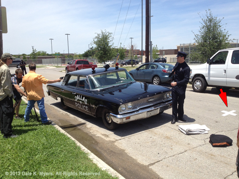 |
FIG. 25 – A replica of Tippit’s squad car with the newly finished ‘X’, marking the spot where Tippit fell, superimposed (arrow) to show the relationship of the ‘X’ to the car. Taken during the filming of the 2013 History Channel special “Oswald: 48 Hours to Live.” (© 2013 Dale K. Myers. All Rights Reserved.)
Serving history
Within hours of the team completing the project, a JFK Tour trolley bus rumbled down Tenth Street. The trolley pulled up to the painted ‘X’ and the tour guide was heard to tell his passengers, “The ‘X’ marks the spot where Dallas Patrolman J.D. Tippit was shot and killed on November 22, 1963.”
Lest we forget. [END]
Footnotes
1. Memorandum to File, May 3, 2001, p.8 – Dale K. Myers Collection
2. W.E. Barnes’ Tippit crime scene sketches, November 22, 1963 – DMARC
3. Ibid.
4. Memorandum to File, May 3, 2001, pp.17-18 – Dale K. Myers Collection
5. Ibid., pp.38-39
6. Envelope (front), DMARC 91-001-0901016a, 2562
7. List, “Photos available in the J.D. Tippit Shooting plus Texas Theater where Oswald arrested,” DMARC 91-001-1154001, 4078, 15
8. Warren Commission CD630 – FBI Briefing Book, “The Assassination of President John F. Kennedy, November 22, 1963, Killing of Dallas Patrolman J.D. Tippit, March 26, 1964, pp.1-45
9. Ibid., “Diagram and Photographs of Immediate Area – Tippit Killing Site,” p.6
10. Darryl Heikes Collection, Exposures Nos. 9 and 10, The Sixth Floor Museum at Dealey Plaza
11. Vanishing point – https://en.wikipedia.org/wiki/Vanishing_point
12. Additional personnel on hand to assist Brown and Badalson were: Freda Dillard, Matthew Kordelski, Fred Litwin, Ed Murray, and Steve Roe.